


st Rigaud

CatherinePerrin
User
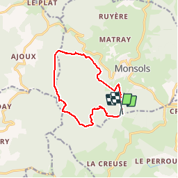

Length
11.2 km

Max alt
1007 m

Uphill gradient
473 m
Km-Effort
17.6 km

Min alt
573 m

Downhill gradient
497 m
Boucle
Yes
Creation date :
2019-06-16 12:33:33.955
Updated on :
2019-06-16 17:37:20.077
3h16
Difficulty : Very easy

FREE GPS app for hiking
 SityTrail
IGN / Geographical institutes
SityTrail Plus
The world is yours!
About
Trail Walking of 11.2 km to be discovered at Auvergne-Rhône-Alpes, Rhône, Les Ardillats. This trail is proposed by CatherinePerrin.
Positioning
Country:
France
Region :
Auvergne-Rhône-Alpes
Department/Province :
Rhône
Municipality :
Les Ardillats
Location:
Unknown
Start:(Dec)
Start:(UTM)
616849 ; 5117780 (31T) N.
Comments